 Larger
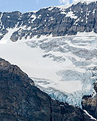
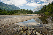
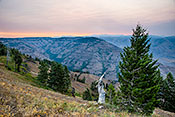
 #5174 Crowfoot Glacier and Lake (Jul 17, 2009), Jasper National Park, Jasper, AB, 3
 Larger
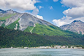
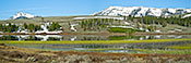
 #5064 Moose Pass Panorama (Jun 28, 2009), Seward Highway, Anchorage, AK, 3
 Larger
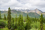
 #5059 View from the Snow Line (Jun 27, 2009), Arctic Valley, Anchorage, AK, 2
 Larger
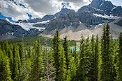
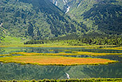
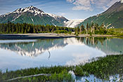
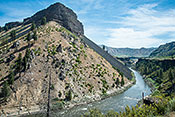
 #5065 Tern Lake Reflecting Wrong Mountain (Jul 01, 2009), Seward Highway, Anchorage, AK, 3
 Larger
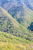
 #5023 Sun Dappled Volcanic Hills (Jun 21, 2009), Wrangell - Saint Elias National Park, Gakona, AK, 3
 Larger
 #5026 Sheep Mountain with Volcanic Soil (Jun 21, 2009), Wrangell - Saint Elias National Park, Gakona, AK, 3
 Larger
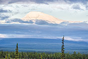
 #5024 Mount Sanford Above the Clouds (Jun 21, 2009), Wrangell - Saint Elias National Park, Gakona, AK, 3
 Larger
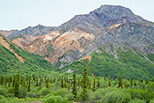
 #5022 From Rock Lake Campsite -- Noyes Mountain (Jun 20, 2009), Wrangell - Saint Elias National Park, Gakona, AK, 4
 Larger
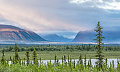
 #5025 Upper Copper River Valley in Misty Morning Light (Jun 21, 2009), Wrangell - Saint Elias National Park, Gakona, AK, 4
 Larger
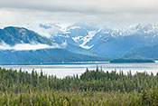
 #4990 Mendenhall Glacier from Ferry (Jun 17, 2009), Inside Passage -- Petersburg to Haines, Haines, AK, 3
 Larger
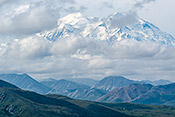
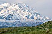
 #5149 Denali -- Classic View (Jul 10, 2009), Denali National Park -- Thoro Pass Ranger Hike, Healy, AK, 3
 Larger
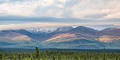
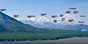
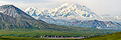
 #5107 Denali Peaks Identified (Jul 08, 2009), Denali National Park -- On the bus, Healy, AK, 3
 Larger
 #5154 Denali with Cumulous Clouds (Jul 10, 2009), Denali National Park -- Thoro Pass Ranger Hike, Healy, AK, 4
 Larger
 #5167 Polychrome Mountains Panorama (Jul 09, 2009), Denali National Park -- Polychrome Mountains, Healy, AK, 3
 Larger
 #5147 Polychrome Mountains and Braided Stream (Jul 10, 2009), Denali National Park -- Polychrome Mountains, Healy, AK, 3
 Larger
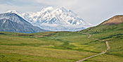
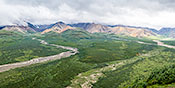
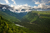
 #5148 Denali and the Park Road (Jul 10, 2009), Denali National Park -- Thoro Pass Ranger Hike, Healy, AK, 3
 Larger
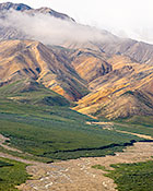
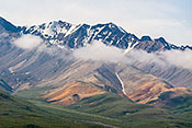
 #5146 Polychrome Mountains in Morning Light (Jul 10, 2009), Denali National Park -- Polychrome Mountains, Healy, AK, 3
 Larger
 #5150 Denali from Thoro Pass (Jul 10, 2009), Denali National Park -- Thoro Pass Ranger Hike, Healy, AK, 4
 Larger
 #4980 LeConte Glacier and Icebergs (Jun 16, 2009), Tongass National Forest -- Mitkof Island, Petersburg, AK, 3
 Larger
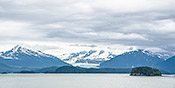
 #5067 Mount Marathon Above Seward (Jun 29, 2009), Kenai Fjords National Park -- Cruise, Seward, AK, 3
 Larger
 #5081 Cirque Glaciers and Fishing Boat (Jun 29, 2009), Kenai Fjords National Park -- Cruise, Seward, AK, 3
 Larger
 #5100 Exit Glacier Reflected in the Resurrection River (Jul 01, 2009), Kenai Fjords National Park -- Exit Glacier, Seward, AK, 3
 Larger
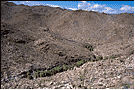
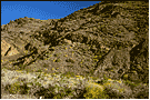
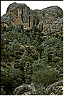
 #3532 Peralta Trail from a Distance (Mar 25, 2005), Tonto NF Superstition Wilderness Area, Apache Junction, AZ, 4
 Larger
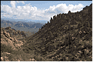
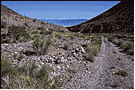
 #3399 Looking Back South along the Peralta Trail (Feb 23, 2005), Tonto NF Superstition Wilderness Area, Apache Junction, AZ, 2
 Larger
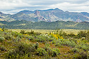
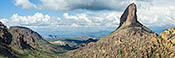
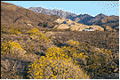
 #3401 Weaver's Needle Panorama (Feb 23, 2005), Tonto NF Superstition Wilderness Area, Apache Junction, AZ, 4
 Larger
 #2787 Mule Ascending to Cedar Ridge (Feb 21, 2003), Grand Canyon South Rim AZ 64 Area, Grand Canyon, AZ, 2
 Larger
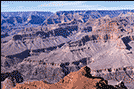
 #2782 Panorama from Pima Point (Feb 21, 2003), Grand Canyon West Rim Drive, Grand Canyon, AZ, 2
 Larger
 #1667 Boundary Cone Ute Mountains (Mar 12, 2001), Warm Springs Wilderness / Oatman, Kingman, AZ, 2
#1857 Vermilion Cliffs Overview (Mar 20, 1999), Vermilion Cliffs, Page, AZ, 2
#3494 Palm Canyon Distant View (Mar 20, 2005), Kofa National Wildlife Refuge, Quartzsite, AZ, 2
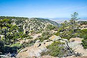
#2767 View from Coronado Peak (Feb 17, 2003), Coronado National Memorial, Sierra Vista, AZ, 2
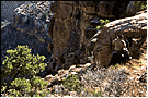
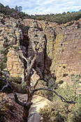
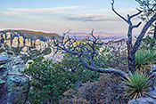
#2771 Rock Formation and Lichen (Feb 19, 2003), Carr Canyon and Mountain, Sierra Vista, AZ, 3
 Larger
 #3030 Sulfur Springs Valley from Inspiration Point (Mar 30, 2011), Chiricahau National Monument, Willcox, AZ, 4
 Larger
 #3020 Sulfur Springs Valley Overlook (Mar 31, 2011), Chiricahau National Monument, Willcox, AZ, 4
 Larger
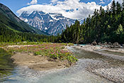
 #5171 Mount Robson as Seen from the Robson River (Jul 17, 2009), Mount Robson Provincial Park, Mount Robson, BC, 4
 Larger
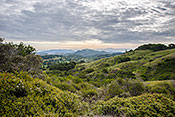
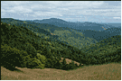
 #4723 A View from Pine Mountain Truck Trail (Apr 30, 2009), Marin Municipal Watershed -- Pine Mountain, Fairfax, CA, 4
 Larger
 #3130 The King Range of the Lost Coast Overview (Jun 09, 2004), King's Range Mattole River Road and Beach, Ft. Bragg, CA, 2
 Larger
 #3452 Photographer Capturing Panamint Reflection (Mar 16, 2005), Death Valley NP, Furnace Creek, CA, 4
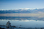 Larger
 #5250 The Panamint Range Reflected in Salt Creek (Mar 07, 2010), Death Valley NP, Furnace Creek, CA, 4
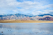 Larger
 #1514 Sagebrush Valley Traversed by Titus Canyon Road (Apr 15, 2009), Death Valley NP Titus Canyon (Amagorsa Mtns.), Inyo County, CA, 2
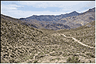 Larger
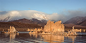
 #3051 Tufa Towers with the High Sierras Behind (Apr 19, 2004), Mono Lake, Lee Vining, CA, 3
 Larger
 #3056 Rush Creek in Early Spring (Apr 19, 2004), June Lake Loop, Lee Vining, CA, 2
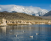
#3052 California Gulls in Mono Lake (Apr 19, 2004), Mono Lake, Lee Vining, CA, 3
 Larger
 #1802 Modeska Canyon Overlook (Dec 20, 1997), Cleveland National Forest Harding Truck Trail, Modjeska, CA, 2
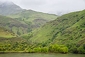
#1804 Harding Truck Trail and Orange County from Three Mile Point (Dec 20, 1997), Cleveland National Forest Harding Truck Trail, Modjeska, CA, 2
#1805 Santiago Reservoir, LA Basin, Distant San Gabriels (Dec 20, 1997), Cleveland National Forest Harding Truck Trail, Modjeska, CA, 2
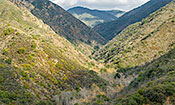
#1784 Harding Canyon Overlook (Jan 25, 2006), Cleveland National Forest Harding Canyon, Modjeska, CA, 4
 Larger
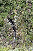
 #7634 Mountainside with Water Cascade (Mar 16, 2023), Cleveland National Forest Harding Truck Trail, Modjeska, CA, 3
 Larger
 #2213 Palm Grove in Carrizo Gorge (Mar 16, 2003), Anza-Borrego Desert Piedras Grandes, Ocotillo, CA, 2
 Larger
 #2023 Two Pane Panorama of Mountainside (Mar 26, 2002), Oroville Table Mountain, Oroville, CA, 2
#2982 Panamint Foothills Campsite (Mar 27, 2004), Death Valley NP Panamint Mountains, Panamint Springs, CA, 2
 Larger
 #2988 Johnson Canyon Road (Mar 27, 2004), Death Valley NP Panamint Mountains, Panamint Springs, CA, 2
 Larger
 #2983 Johnson Canyon Side Covered with Brittlebush (Mar 27, 2004), Death Valley NP Panamint Mountains, Panamint Springs, CA, 2
 Larger
 #2980 Brittlebush Lining the Ravine (Mar 27, 2004), Death Valley NP Panamint Mountains, Panamint Springs, CA, 2
#2979 Death Valley Overview from Johnson Canyon Road at Dawn (Mar 27, 2004), Death Valley NP Panamint Mountains, Panamint Springs, CA, 2
#2689 Gray Pines and Pinnacles (Dec 24, 2002), Pinnacles National Monument, Soledad, CA, 2
 Larger
 #2025 Snowfield near Donner Lake (Mar 26, 2002), Donner Lake, Truckee, CA, 2
#2024 Donner Lake from I-80 Rest Area Showing Railroad Snow Sheds (Mar 26, 2002), Donner Lake, Truckee, CA, 2
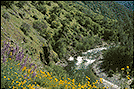
#2809 Poppies, Lupine, Trail and South Fork of Merced (Mar 31, 2003), Hite Cove Trail, Yosemite, CA, 2
 Larger
 #1981 Ahwiyah Point Reflected in Mirror Lake (Mar 23, 2002), Yosemite National Park, Yosemite Village, CA, 2
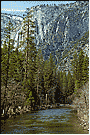
#2475 Merced River and Yosemite Falls from Bridge (Mar 23, 2002), Yosemite National Park, Yosemite Village, CA, 2
 Larger
 #2817 Redbuds along the Merced (Mar 31, 2003), Yosemite National Park, Yosemite Village, CA, 2
 Larger
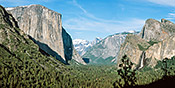
 #1982 Yosemite Valley Panorama from Tunnel View (Mar 23, 2002), Yosemite National Park, Yosemite Village, CA, 4
 Larger
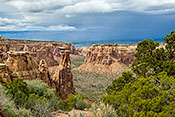
 #1854 Monument Canyon on a Stormy Day (Apr 24, 2005), Colorado National Monument, Fruita, CO, 3
 Larger
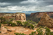
 #1853 View from the End of the Otto Trail (Apr 24, 2005), Colorado National Monument, Fruita, CO, 3
 Larger
 #1852 Colorado Panorama with Farmhouse and Spanish Peaks in Background (Mar 14, 2001), Along US 160, Pagosa Springs, CO, 2
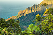
#4481 Kalalau Valley at Sun Down (Jan 19, 2008), Kalalau Valley, Haena, HI, 3
 Larger
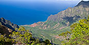
 #4484 Kalalau Valley Panorama (Jan 20, 2008), Kalalau Valley, Haena, HI, 3
 Larger
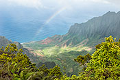
 #4486 Rainbow over the Valley (Jan 21, 2008), Kalalau Valley, Haena, HI, 3
 Larger
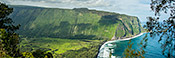
 #4434 Waipio Valley Panorama (Jan 17, 2008), Waipio Valley, Honoka'a, HI, 3
 Larger
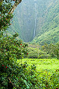
 #4438 Hiilawe Falls from Waipio Valley Floor (Jan 17, 2008), Waipio Valley, Honoka'a, HI, 3
 Larger
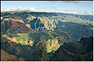
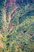
 #4489 Waimea Canyon Overview (Jan 19, 2008), Waimea Canyon, Waimea, HI, 2
 Larger
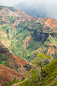
 #4492 Canyon Wall Detail (Jan 21, 2008), Waimea Canyon, Waimea, HI, 3
 Larger
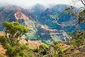
 #4490 Waimea Canyon in the Mist (Jan 21, 2008), Waimea Canyon, Waimea, HI, 4
 Larger
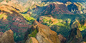
 #4488 Waimea Canyon Panorama (Jan 19, 2008), Waimea Canyon, Waimea, HI, 3
 Larger
 #4473 Mauna Kea Observatories above the Clouds (Jan 12, 2008), Parker Ranch, Waimea, HI, 3
 Larger
 #4493 Canyon Slopes (Jan 21, 2008), Waimea Canyon, Waimea, HI, 3
 Larger
 #437 Flatiron Mountain Beside the Boise River (Jul 05, 2014), Blacks Creek Road, Boise, ID, 3
 Larger
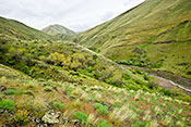
 #6089 Brownlee Creek Valley in Spring (May 04, 2012), Hells Canyon NRA Along ID 71, Cambridge, ID, 3
 Larger
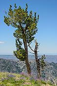
 #472 Whitebark Pine on the Edge (Jul 10, 2014), Hells Canyon NRA Seven Devils Recreation Site, Riggins, ID, 3
 Larger
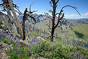
 #6692 Wildflowers in a Burned Forest at Heaven's Gate (Jul 10, 2014), Hells Canyon NRA Seven Devils Recreation Site, Riggins, ID, 3
 Larger
 #6367 Striped Landscape - Meadow, Forest, Rock, Sky (Aug 22, 2013), Hells Canyon NRA Seven Devils Recreation Site, Riggins, ID, 3
 Larger
 #3761 Baxter Peak on Mt. Katahdin (Sep 07, 2005), Baxter State Park, Millinocket, ME, 2
 Larger
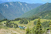
 #6430 Ascending to Iceberg Lake 4. Distant Glacier View (Sep 09, 2013), Glacier National Park Iceberg Lake Trail, Babb, MT, 4
 Larger
 #6427 Ascending to Iceberg Lake 1. U-shaped Valley (Sep 09, 2013), Glacier National Park Iceberg Lake Trail, Babb, MT, 4
 Larger
 #5181 Lunch Creek and Snow Field (Jul 18, 2009), Glacier National Park Going to the Sun, West Glacier, MT, 4
 Larger
 #6424 Mt. Oberlin Close-up Panorama (Sep 07, 2013), Glacier National Park Going to the Sun, West Glacier, MT, 3
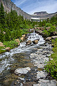
 Larger
 #6401 McDonald Creek Cascade (Sep 05, 2013), Glacier National Park Lake McDonald Lake, West Glacier, MT, 4
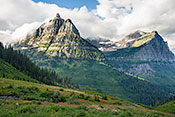
 Larger
 #6425 Mt. Oberlin and Mt. Cannon with Gathering Clouds (Sep 07, 2013), Glacier National Park Going to the Sun, West Glacier, MT, 4
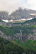
 Larger
 #6423 Mt. Oberlin with Bird Woman Falls (Sep 07, 2013), Glacier National Park Going to the Sun, West Glacier, MT, 4
 Larger
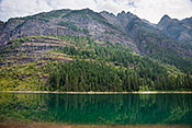
 #6400 Glacier Peak Reflected in McDonald Creek (Sep 05, 2013), Glacier National Park Lake McDonald Lake, West Glacier, MT, 4
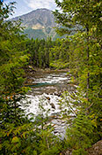
 Larger
 #6422 McDonald Creek Valley (Sep 07, 2013), Glacier National Park Going to the Sun, West Glacier, MT, 4
 Larger
 #6413 Ascending to Avalanche Lake 10. Avalanche Lake Reflections (Sep 06, 2013), Glacier National Park Avalanche Creek Trail, West Glacier, MT, 4
 Larger
 #2531 The Cottonstone Escarpment (Oct 13, 2003), Native Plant Discovery, Orford, NH, 4
 Larger
 #2528 View from the North Side of Cottonstone in Fall (Oct 13, 2003), Native Plant Discovery, Orford, NH, 2
#4039 Connecticut River Valley in Spring (May 10, 2006), Native Plant Discovery, Orford, NH, 4
 Larger
 #2530 Looking South from Cottonstone to Smarts Mountain (Oct 13, 2003), Native Plant Discovery, Orford, NH, 2
#2519 Wildflower Meadow with a View of Mount Washington (Sep 24, 2007), White Mountains of New Hampshire, Sugar Hill, NH, 3
 Larger
 #2527 Snowy Summit of Mt. Lafayette (Oct 06, 2003), White Mountains of New Hampshire, Sugar Hill, NH, 2
#3280 From Marsh to Mountains (Dec 22, 2004), Bosque del Apache NWR, Socorro, NM, 2
#3290 Snow Geese Flying in a Snowy Mountain Landscape (Dec 23, 2004), Bosque del Apache NWR, Socorro, NM, 4
 Larger
 #3281 Marsh and Chupadara Mountains (Dec 22, 2004), Bosque del Apache NWR, Socorro, NM, 3
 Larger
 #6053 Wheeler Peak Panorama (May 01, 2012), Great Basin National Park, Baker, NV, 3
 Larger
 #2972 Ash Meadows at Dawn (Mar 26, 2004), Ash Meadows NWR, Pahrump, NV, 2
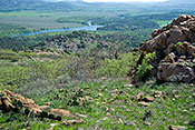
#3252 Mount Baldy (Dec 18, 2004), Wichita Mountains NWR, Lawton, OK, 2
#6008 French Lake as Seen From Elk Mountainside (Mar 31, 2012), Wichita Mountains NWR, Lawton, OK, 2
 Larger
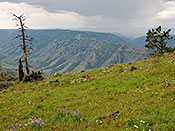
 #3176 A Stormy Day at Hat Point Overlook (Jun 18, 2004), Hells Canyon NRA, Joseph, OR, 3
 Larger
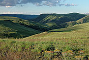
 #3158 The Prairie with Foothills and Mountains in the Distance (Jun 19, 2004), Zumwalt Prairie, Joseph, OR, 3
 Larger
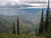
 #3174 Storm over Imnaha Canyon (Jun 18, 2004), Hells Canyon NRA, Joseph, OR, 3
 Larger
 #6383 Hells Canyon Overlook at Dawn (Aug 27, 2013), Hells Canyon NRA, Joseph, OR, 3
 Larger
 #6192 Idaho Shore from Brownlee Oxbow Highway (May 04, 2012), Hells Canyon NRA, Joseph, OR, 3
 Larger
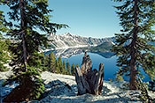
 #3154 Crater Lake with Cone and Dead Stump (Jun 15, 2004), Crater Lake National Park, Medford, OR, 3
 Larger
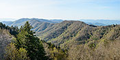
 #1059 Newfound Gap Panorama (May 06, 2014), Great Smoky Mountains (US 441 to Newfound Gap), Gatlinburg, TN, 3
 Larger
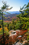
 #1016 Mountainside in Spring (May 06, 2014), Great Smoky Mountains (US 441 to Newfound Gap), Gatlinburg, TN, 3
 Larger
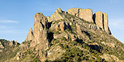
 #4230 The Casa Grande of the Chisos Mountains (Mar 06, 2007), Big Bend National Park Chisos Mtns, Alpine, TX, 3
 Larger
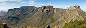
 #4232 Panorama from the Top of the Lost Mine Trail (Mar 06, 2007), Big Bend National Park Chisos Mtns, Alpine, TX, 3
 Larger
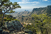
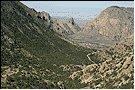
 #4233 The Rio Grande Valley from the Lost Mine Trail (Mar 06, 2007), Big Bend National Park Chisos Mtns, Alpine, TX, 3
 Larger
 #4234 The Chisos Mountain Basin Overlook from the Lost Mine Trail (Mar 06, 2007), Big Bend National Park Chisos Mtns, Alpine, TX, 2
 Larger
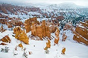
 #1994 Bryce Amphitheater from Sunset Point (Mar 15, 2010), Bryce Canyon National Park, Escalante, UT, 4
 Larger
 #3058 Rock Formation Overlooking the San Rafael Swell (Apr 20, 2004), Along I-70, Green River, UT, 2
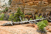
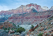
#3626 Bleached Log on Sandstone Slick Rock (Apr 22, 2005), Zion NP East of the Tunnel, Springdale, UT, 4
 Larger
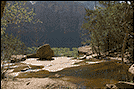
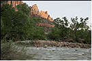
 #1825 Pool and Canyon (Apr 19, 2005), Zion NP, Springdale, UT, 2
 Larger
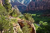
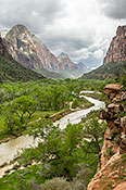
 #1833 Zion Canyon from the Kayenta Trail with Storm Brewing (Apr 19, 2005), Zion NP, Springdale, UT, 3
 Larger
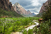
 #1824 Zion Canyon from the Emerald Pools Trail (Apr 19, 2005), Zion NP, Springdale, UT, 3
 Larger
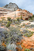
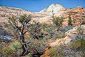
 #5263 Vegetation on Slickrock (Mar 13, 2010), Zion NP East of the Tunnel, Springdale, UT, 4
 Larger
 #5271 Weathered Log on Sandstone (Mar 14, 2010), Zion NP East of the Tunnel, Springdale, UT, 4
 Larger
 #3620 The Virgin River at the Watchman Campgrounds (Apr 21, 2005), Zion NP, Springdale, UT, 2
 Larger
 #5269 Shrubs on Sandstone (Mar 14, 2010), Zion NP East of the Tunnel, Springdale, UT, 4
 Larger
 #1832 Virgin River from Kayenta Trail with Stormy Sky (Apr 19, 2005), Zion NP, Springdale, UT, 4
 Larger
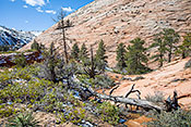
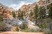
 #5266 High Country Wash (Mar 13, 2010), Zion NP East of the Tunnel, Springdale, UT, 4
 Larger
 #5255 Looking Across the Virgin River Valley (Mar 13, 2010), Zion NP, Springdale, UT, 4
 Larger
 #3633 View of Chimney Rock (Apr 23, 2005), Capitol Reef NP UT 24 and Scenic Drive, Torrey, UT, 2
#2649 Tantalus Flats and Capitol Reef from US 12 (Dec 19, 2002), Capitol Reef NP UT 24 and Scenic Drive, Torrey, UT, 2
 Larger
 #3634 Chimney Rock and Pine (Apr 23, 2005), Capitol Reef NP UT 24 and Scenic Drive, Torrey, UT, 2
 Larger
 #504 Colorful Volcanic Rock on Mt. Rainier South Face (Jul 31, 2014), Mt. Rainier National Park Paradise Area, Ashford, WA, 3
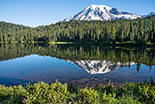
 Larger
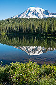
 #6345 Mt Rainier Reflection in Reflection Lake (Jul 31, 2014), Mt. Rainier National Park Stevens Canyon Road, Ashford, WA, 4
 Larger
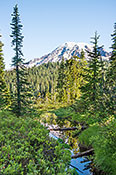
 #6821 Mt. Rainier Reflected in a Narrow Stream (Jul 31, 2014), Mt. Rainier National Park Stevens Canyon Road, Ashford, WA, 4
 Larger
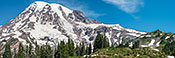
 #498 Mt. Rainier South Face (Jul 31, 2014), Mt. Rainier National Park Paradise Area, Ashford, WA, 3
 Larger
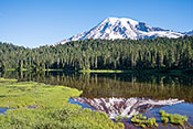
 #6820 Mt. Rainier Reflection Framed by Marsh Grass (Jul 31, 2014), Mt. Rainier National Park Stevens Canyon Road, Ashford, WA, 4
 Larger
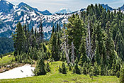
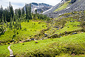
 #6833 Alpine Forest with Distant View of Mt. Adams (Jul 31, 2014), Mt. Rainier National Park Paradise Area, Ashford, WA, 4
 Larger
 #6825 Mt. Rainier Panorama in Brilliant Sunshine (Jul 31, 2014), Mt. Rainier National Park Paradise Area, Ashford, WA, 4
 Larger
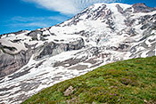
 #508 Glacial and Snowfield Runoff (Jul 31, 2014), Mt. Rainier National Park Paradise Area, Ashford, WA, 3
 Larger
 #6840 Mt. Rainier Reflection Portrait (Jul 31, 2014), Mt. Rainier National Park Stevens Canyon Road, Ashford, WA, 4
 Larger
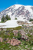
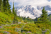
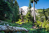
 #6322 Mt. Rainier Looms Above a Wildflower Meadow (Aug 14, 2013), Mt. Rainier National Park Paradise Area, Ashford, WA, 4
 Larger
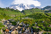
 #6323 Mt. Rainier from the Paradise Stream Crossing (Aug 14, 2013), Mt. Rainier National Park Paradise Area, Ashford, WA, 3
 Larger
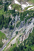
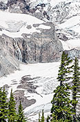
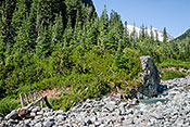
 #6829 Wilson Glacier Waterfall (Jul 31, 2014), Mt. Rainier National Park Paradise Area, Ashford, WA, 4
 Larger
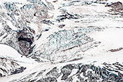
 #6830 Wilson Glacier Details (Jul 31, 2014), Mt. Rainier National Park Paradise Area, Ashford, WA, 4
 Larger
 #6309 Mount Saint Helens Panorama McClellan Overlook Afternoon Light (Aug 12, 2013), Mt. St. Helens National Volcanic Monument South, Carson, WA, 3
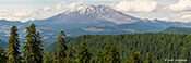 Larger
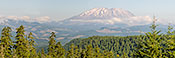
 #6310 Mount Saint Helens Panorama McClellan Overlook Morning Light (Aug 13, 2013), Mt. St. Helens National Volcanic Monument South, Carson, WA, 4
 Larger
 #6758 Alpine Meadow with Glacial Tarn (Jul 25, 2014), Olympic National Park -- Lillian Ridge Trail, Port Angeles, WA, 3
 Larger
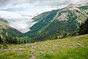
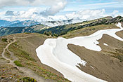
 #6752 U-Shaped Valley Filled with Clouds (Jul 24, 2014), Olympic National Park -- Obstruction Point Road, Port Angeles, WA, 3
 Larger
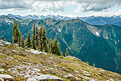
 #6773 The Lillian Ridge Trail Above the Tree Line (Jul 25, 2014), Olympic National Park -- Lillian Ridge Trail, Port Angeles, WA, 3
 Larger
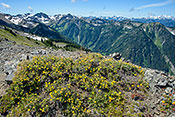
 #6765 Shrubby Cinquefoil on an Alpine Ridge (Jul 25, 2014), Olympic National Park -- Lillian Ridge Trail, Port Angeles, WA, 3
 Larger
 #6779 Heath Flowers in a Meadow with the Olympic Mountains Behind (Jul 25, 2014), Olympic National Park -- Lillian Ridge Trail, Port Angeles, WA, 3
 Larger
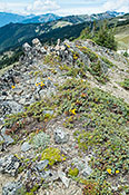
 #6777 Ground Juniper and Wildflowers on a Dry Ridge (Jul 25, 2014), Olympic National Park -- Lillian Ridge Trail, Port Angeles, WA, 3
 Larger
 #6317 Along the Meta Lake Trail (Aug 13, 2013), Mt. St. Helens National Volcanic Monument North, Randle, WA, 4
 Larger
 #6316 View from Bear Meadow (Aug 13, 2013), Mt. St. Helens National Volcanic Monument North, Randle, WA, 4
 Larger
 #6813 Ascending to Summerland 9: Summerland Meadow and Glacier (Jul 30, 2014), Mt. Rainier National Park Summerland Trail, White River Entrance, WA, 4
 Larger
 #6811 Ascending to Summerland 7: Frying Pan Glacier (Jul 30, 2014), Mt. Rainier National Park Summerland Trail, White River Entrance, WA, 4
 Larger
 #6814 Ascending to Summerland A: Wonderland Trail (Jul 30, 2014), Mt. Rainier National Park Summerland Trail, White River Entrance, WA, 4
 Larger
 #6812 Ascending to Summerland 8: Picnic Log (Jul 30, 2014), Mt. Rainier National Park Summerland Trail, White River Entrance, WA, 4
 Larger
 #6809 Ascending to Summerland 5: Crossing Frying Pan Creek (Jul 30, 2014), Mt. Rainier National Park Summerland Trail, White River Entrance, WA, 4
 Larger
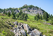
 #6804 Naches Peak (6400 ft.) East Face (Jul 29, 2014), Mt. Rainier National Park Natches Pk Loop Trail, White River Entrance, WA, 3
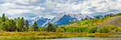
 Larger
 #6306 Teton Range Reflected in the Snake River (Aug 07, 2013), Grand Teton National Park Along US 89 and 191, Jackson (Hole), WY, 3
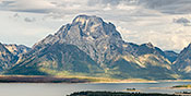
 Larger
 #6489 Mt. Moran in Morning Light (Sep 17, 2013), Grand Teton National Park Teton Park Road, Jackson (Hole), WY, 4
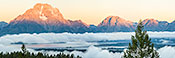
 Larger
 #6488 Sunrise Panorama of the Teton Range from Signal Mountain (Sep 20, 2013), Grand Teton National Park Teton Park Road, Jackson (Hole), WY, 4
 Larger
 #6487 Teton Range Panorama from Signal Mountain Viewpoint (Sep 16, 2013), Grand Teton National Park Teton Park Road, Jackson (Hole), WY, 4
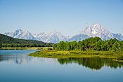
#6486 Teton Range Panorama from Oxbow Bend (Sep 17, 2013), Grand Teton National Park Along US 89 and 191, Jackson (Hole), WY, 4
 Larger
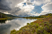
 #6484 Storm over the Teton Range from the Snake River Oxbow Bend (Sep 16, 2013), Grand Teton National Park Along US 89 and 191, Jackson (Hole), WY, 4
 Larger
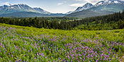
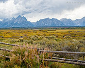
 #6464 Fireweed, Sagebrush, and Willows in a Mountain Meadow (Sep 16, 2013), Grand Teton National Park Along US 89 and 191, Jackson (Hole), WY, 3
 Larger
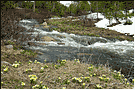
 #3163 Globeflowers Lining Stream (Jun 04, 2004), Medicine Bow National Forest Snowy Mountains, Laramie, WY, 2
 Larger
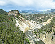
 #6181 Calcite Springs on the Yellowstone River (May 16, 2012), Yellowstone Grand Loop Mammoth to Tower, Mammoth, WY, 3
 Larger
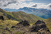
 #6106 The Gallatin Range (May 14, 2012), Yellowstone US 89 Mammoth to Madison Junction, Mammoth, WY, 3
 Larger
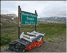
 #4998 Haines Highway Summit (Jun 18, 2009), Alaska Highway -- Yukon Highway 1, Haines Junction, YT, 2
 Larger